System type: Sediment-hosted Carlin-type
Target: Fault-controlled and disseminated gold
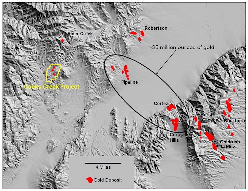
The Cooks Creek project covers an area of outcropping sediment-hosted gold mineralization along the Cortez Trend about 8 miles west of the world-class Pipeline mine in north-central Nevada. The Pipeline and adjacent Cortez and Cortez Hills Carlin-type gold deposits contain more than 25 million ounces of gold (production plus reserves/resources); the mines are operated by Barrick Gold Corporation.
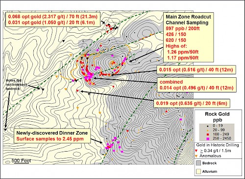
At least three and possibly four northeast-striking high-angle faults localize gold mineralization within a section of western-facies siliciclastic rocks across at least 4,500 feet in a north-south direction near the edge of a large alluvial basin. The Main gold zone at Cooks Creek covers an area of at least 3,400 by 1,700 feet with surface rock-chip assays reaching 1.26 ppm gold over 50 feet (single channel sample). The zone contains strong enrichments in arsenic, mercury, and antimony (locally occurring as stibnite), elements characteristic of productive Carlin-type gold deposits. Mineralization is localized along northeast-trending high-angle faults and hosted by brecciated, argillized to silicified and sulfidized siltstone and chert, and strongly-altered Oligocene felsic volcaniclastics and dikes. Historic drilling (1993-1999) intersected gold mineralization, including 21.3 m @ 2.317 g/t from 18-40 m, 12 m @ 0.516 g/t and 6 m @ 1.05 g/t. Mineralization remains open along strike and depth on at least two northeast-striking fault zones about 1,000 feet apart. The historic drilling did not include any angle holes to properly cross the mineralized faults.
In 2011, a new area of gold mineralization, the Dinner zone, was identified 2,400 feet south of the Main gold zone. The Dinner zone contains silicified and brecciated chert and quartzite along a northeast-trending fault that is parallel to structures controlling gold mineralization at the Main zone. The size of the Dinner zone at surface is uncertain due to extensive alluvial cover, but it appears to be at least 600 feet long by 175 feet wide. Of 31 rock-chip samples collected in the area, 20 exceed 0.1 g/t gold, 8 exceed 1 g/t gold, with a high of 2.45 g/t gold, and these sample results are higher than surface values at the Main zone. Trace elements indicate a favorable Carlin-type gold signature, with strong arsenic (up to 5750 ppm), mercury (up to 57 ppm), and antimony (up to 933 ppm) with low silver, lead and zinc. No drilling has been completed at the Dinner Zone.
Induced-polarization (IP) geophysics was completed in 2011 along a 2.2km line that crosses the structures controlling the Main and Dinner zones. The survey aided in the delineation of important faults at depth and identified a significant IP anomaly under the fault controlling the new Dinner gold zone. This anomaly, possibly the result of deep elevated sulfide content, provides additional support for drill-testing this new zone.
Cooks Creek offers an opportunity to delineate significant, structurally-controlled sediment-hosted gold mineralization along multiple structures and possibly disseminated mineralization along the unconformity between the siliciclastics and overlying volcanics.

Regional topogrpahic map showing location of Cooks Creek Project and productive gold deposits.

Project map showing rock-chip gold and gold in historic drilling.
